Road, Rail or River: Three Routes Through a Region
Compare road, rail and river routes to see which settlements they serve directly, where they meet, and why map distance can differ from a journey.
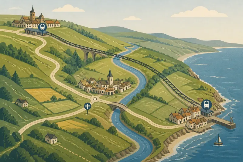
Road, rail and river routes can make the same settlements feel close in different ways. On a regional map, a road’s junctions, a railway’s stations and a river’s direction each suggest a distinct relationship between neighbouring places.
Imagine a hypothetical region called the Vale of Ors. Brindle sits on an inland ridge, Lowmere lies in a valley and Port Ash stands on the coast. A road runs through Brindle and Lowmere to Port Ash; a railway links Brindle and Port Ash but has no station at Lowmere. The Ors River passes Lowmere on its way to the coast. This invented arrangement offers a clear comparison: which places does each route actually serve, and which does it merely pass near?
Start with the places each route reaches
Mark the settlements before tracing their connections. A line can cross a place’s surrounding area without reaching its centre or providing a useful access point. Look for road junctions, station symbols, quays and settlement boundaries. A station beyond a town’s edge may still serve it, but the map should not be read as though the track itself stops at every nearby place.
On the Vale of Ors map, Brindle and Port Ash have railway stations, while Lowmere does not. The road enters all three settlements. The river passes Lowmere and continues towards Port Ash, but that shared course does not by itself show how residents travel between them.
Trace the route to its access point, not just across the map beside the place name.
Roads make junctions and intermediate stops visible
The Vale’s road descends from Brindle to Lowmere, follows the valley, then continues to Port Ash. Lowmere is an intermediate stop because the road enters it; a junction there might also connect the main route with smaller settlements. The road’s bends can reflect the shape of the land or the location of crossings, so its map length may differ from the straight-line gap between two towns.
For road connections, note where the route enters a settlement, where it branches and which places require a detour. A junction can make a town a useful link in several directions, while a road that skirts the centre may serve it less directly than its line suggests.
In this imagined region, a traveller can follow the road from Brindle through Lowmere to Port Ash. That makes Lowmere part of the road journey, even though the railway offers a more direct-looking line between the ridge and the coast.
Railways connect stations, not every place near the track
A railway’s useful connections are defined by its stations and branches. The Vale line passes through the wider valley but stops at Brindle and Port Ash, leaving Lowmere outside the station-to-station link. A resident of Lowmere might reach a station by road or another local connection, but that additional leg should not disappear from the map reader’s mental picture.
Station location matters too. A station on the edge of a settlement can still connect it to other places, though the approach from homes and streets forms part of the journey. Where tracks split, a junction may offer access to more than one route; a branch with no interchange can point towards a narrower set of destinations.
Follow the stops, rather than treating the railway line as a connection to every settlement it crosses.
Compare route relationships without relying on river crossings?
Why can nearby settlements feel far apart?
The route between them may require a detour, or one settlement may lack a station or a direct road connection. Compare actual access points and junctions with the gap between the map symbols.
Does a straighter route connect more places?
Not necessarily. A railway can pass close to a town without stopping there, and a road may skirt its centre; check where the route meets the settlement.
What does a route junction tell me?
A junction shows where a traveller can change direction or transfer between routes. If it sits near a settlement, that place may serve as a link, but the map still needs to show how the settlement itself reaches the junction.
How can I compare road and rail access?
List which places each route reaches directly, then note any extra approach or transfer needed. This makes the comparison about access rather than the apparent straightness of the lines.
Use a simple route comparison to make a decision
For a practical reading, write the settlements down the side of a page and the route types across the top. For each route, record what the map shows: direct access, a nearby but unconnected line, a junction or an extra leg. Then decide which places are linked for the journey you have in mind.
- If a road enters a settlement, mark it as direct road access; if it passes outside without a shown junction, treat access as uncertain and check a more detailed map.
- If a railway station symbol sits in or beside a settlement, mark station access; if the track passes nearby without a station, do not count it as a direct rail link.
- If a road junction appears at a settlement, note the directions it serves; if no branch is shown, do not assume the town connects to other routes there.
- If a route reaches a settlement only after a visible detour, record the detour; if a more direct mapped connection exists, compare that route instead.
- If two route types meet at a station or junction, mark a possible transfer; if no meeting point is shown, keep the routes separate in your comparison.
- If a settlement lies beyond the map edge along a continuing route, note the direction of travel; if the route ends at the edge, leave its onward connection unresolved.
Say you need to compare Brindle, Lowmere and Port Ash on the invented Vale map. Start with the road: it enters all three, so mark direct road access for each. Next check the railway: stations appear at Brindle and Port Ash, but not Lowmere, so mark Lowmere as lacking direct rail access. Finally, note that the river passes Lowmere and continues towards Port Ash, but the map does not show a transport service or landing points. The resulting answer is specific: the road links all three settlements directly; the railway links Brindle and Port Ash by their stations; the river gives Lowmere and Port Ash a shared geographic direction, but not a confirmed travel connection. The trade-off is between the road’s inclusion of Lowmere and the railway’s direct station link between the other two.
Read where the routes lead beyond the region
A route’s direction can connect a settlement to neighbouring regions as well as to places inside the map. Follow roads and railway lines to the map edge, noting whether they pass through a town or meet another route on the way. These details can suggest which place acts as a regional link and which lies at the end of a branch.
In the Vale of Ors, the road makes Lowmere an intermediate stop, while the railway pairs Brindle and Port Ash through their stations. The river shares a broad geographic corridor with Lowmere and the coast, but that is not the same as a mapped transport link. For road, rail or river routes, the useful question is always what the map actually shows: a route nearby, an access point, or a connection between places.
When a settlement looks isolated, inspect its approaches and the map symbols around its edge before deciding it has no links. A nearby junction or station may explain its access; a line that simply passes by does not.